
Camelback Mountain - Cholla Trail vs. Echo Canyon Trail
About Camelback Mountain
Camelback Mountain, located in the heart of the Phoenix metro area, is known for its distinctive shape, which….wait for it….resembles the hump of a camel. Personally, I also think the mountain got its name because any one who dares hike it should come equipped with a Camelbak hydration backpack!
The mountain rises to a height of 2,704 feet and offers stunning views of the surrounding desert landscape. There are two main trails to the summit: Echo Canyon Trail and the Cholla Trail. Both are rated as “DOUBLE BLACK DIAMOND” hiking trails, which means that they feature steep inclines, rocky terrain, narrow paths, and other obstacles that require a high degree of skill, experience, and physical fitness to overcome. These trails are often reserved for experienced hikers who are comfortable with scrambling, bouldering, and other advanced techniques. In other words, NOT US!

Camelback Mountain in Phoenix Arizona (photo taken from South Mountain)
If Justin Timberlake were to tell you about hiking Camelback Mountain, it might go something like this.
I'm hikin’ Camelback (yeah)
I’m strappin’ a big hydration pack (yeah)
I’m getting tired, might have a heart attack (yeah)
Cause this diamond is a double black (yeah)
Take me to the summit.
Way up high (uh-huh)
With you baby, I’ve gotta try (uh huh)
To the top, let’s actualize (uh huh)
My calves hurt, just like my thighs (uh huh)
Take me to the chorus.
Get your hikin’ on (Go ‘head be gone)
At the break of dawn (Go ‘head be gone)
Climb those rocks (Go ‘head be gone)
In your sweaty socks (Go ‘head be gone)
Let’s hike that hill (Go ‘head be gone)
Just need self-will (Go ‘head be gone)
View the town (Go ‘head be gone)
Then scoot back down (Go ‘head be gone)
I’m hikin’ Camelback (yeah)
Climbing boulders on every path (yeah)
Can’t figure out my angle of attack (yeah)
No blue reflector, Guess I’m off the track (yeah)
Take me to the summit.
Can I sing like JT? You can be the judge by watching this video.
Spoiler: I’m no Justin Timberlake.
Cholla Trail on Camelback Mountain
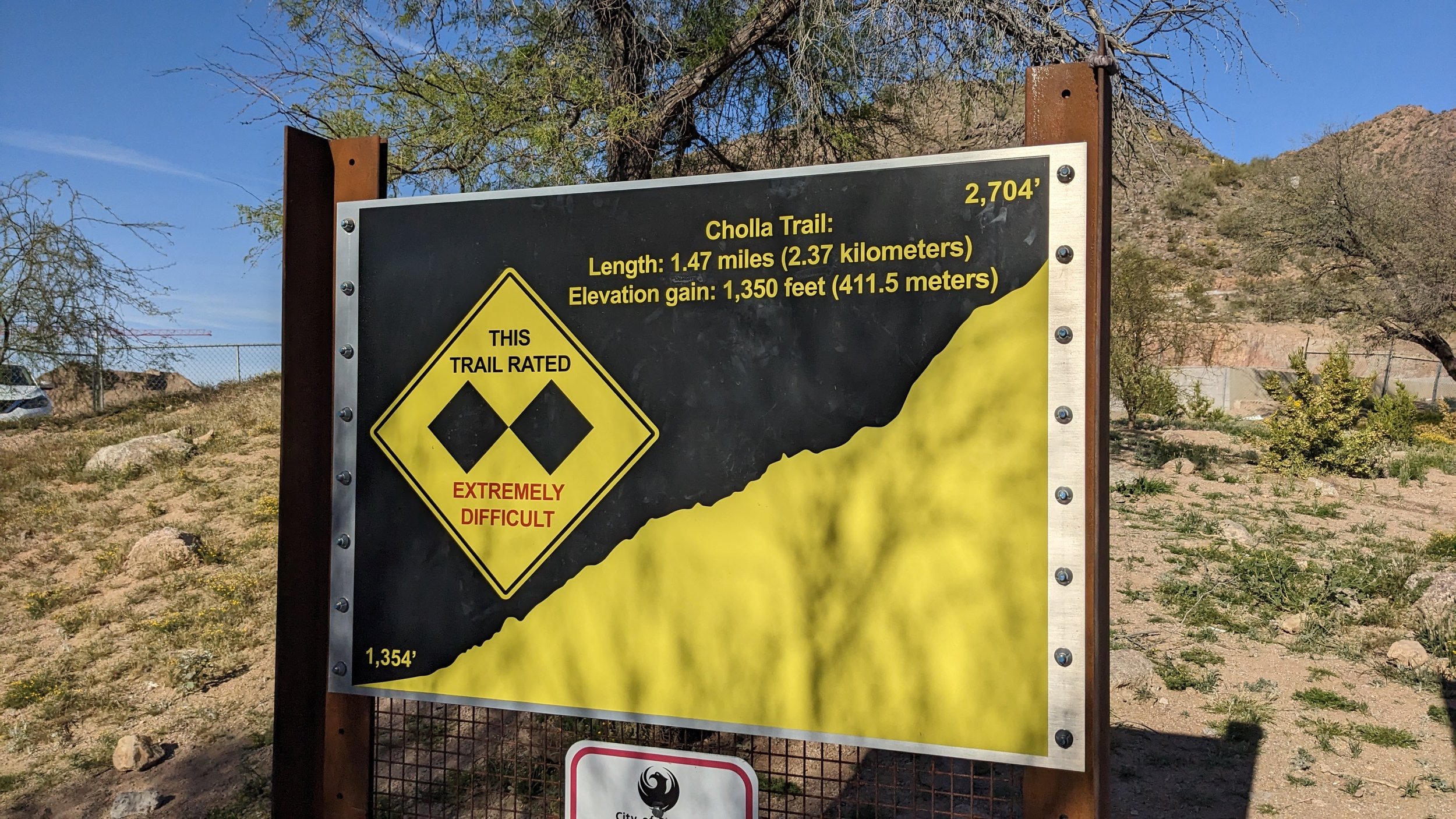
Cholla Trailhead at Camelback Mountain. The trail is a black double-diamond.
The Cholla Trail is a popular hiking trail on Camelback Mountain. It’s considered the easier of the two major trails, and so that was the one that we decided to do (duh!). The trail is located on the eastern side of the mountain and is 1.47 miles long with a gain of 1350 feet. for steep, rocky terrain and bring plenty of water and sunscreen.
The trail begins at the Cholla Trailhead, located just off of Invergordon Road. Parking for the trail is along the road. There are several areas with "NO PARKING" signs or red curbs where cars may not be parked. Depending on the time of day, cars for the trail may be parked as much as a mile away. We arrived mountain around 8:00 am on a Friday, and had to park nearly a half-mile away from the trailhead.
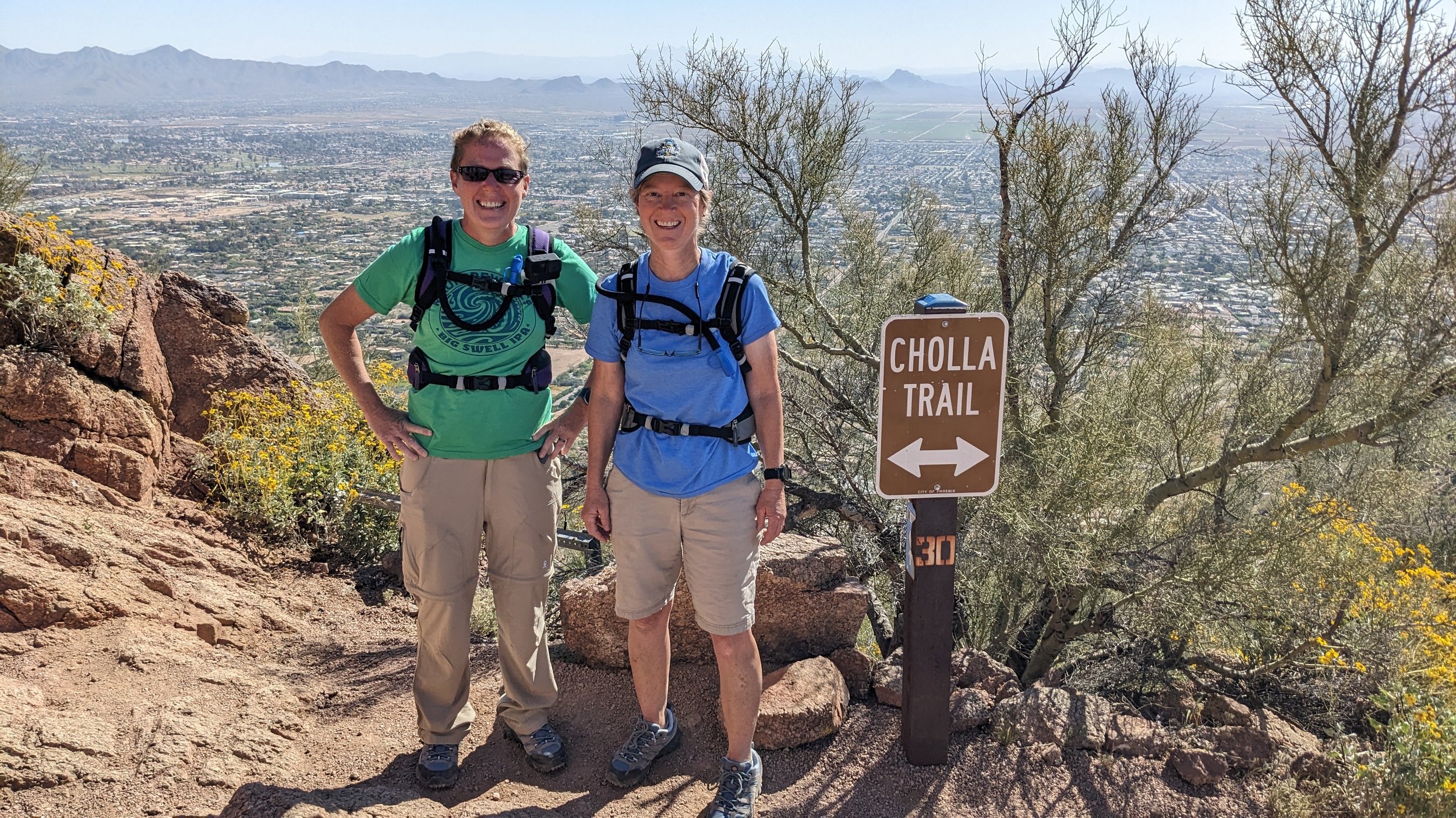
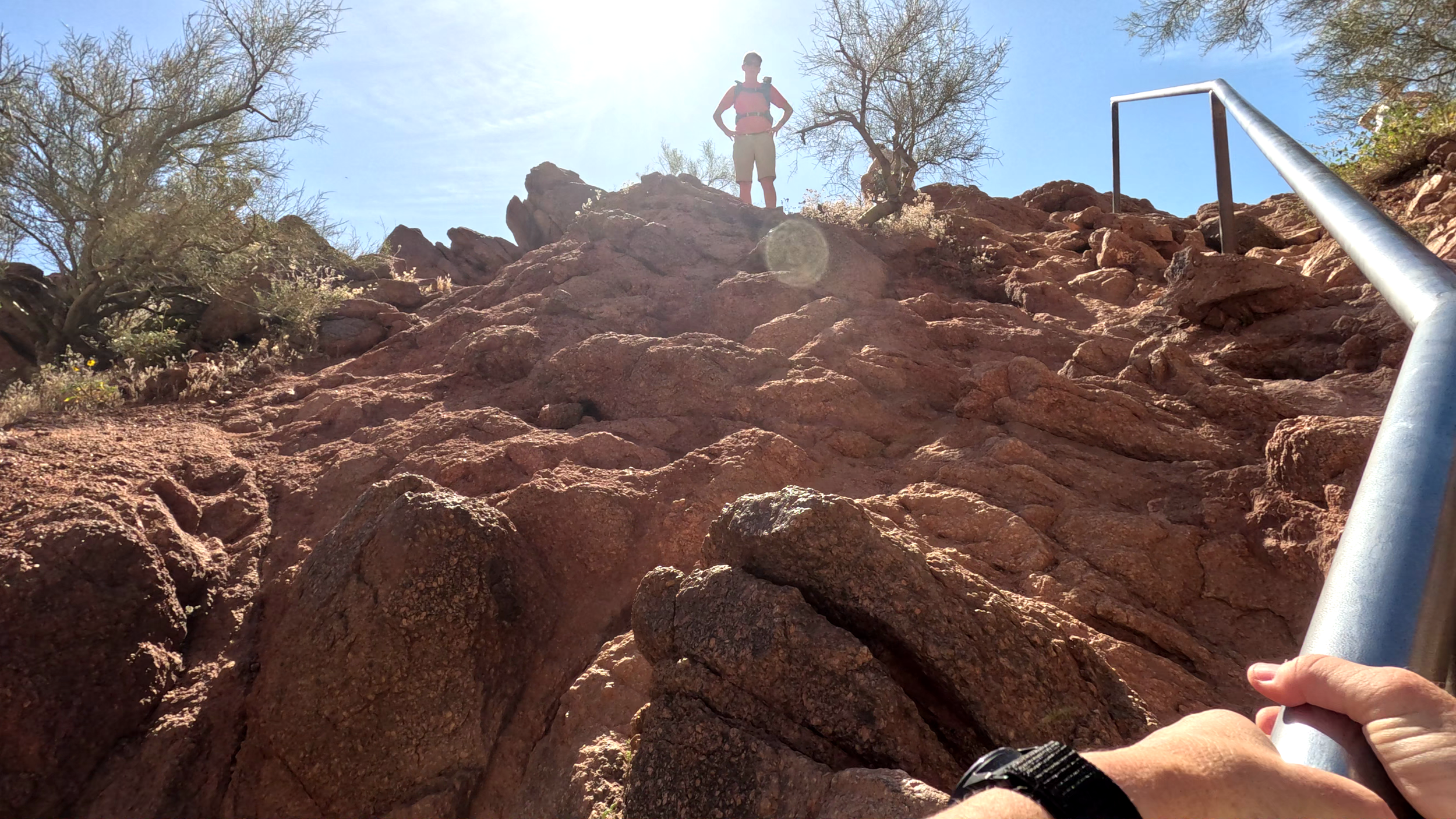
The trail starts with a gentle climb that gradually becomes steeper. Thirty-six numbered signposts help tell hikers how far they have gone (and how far they have to go). The first 2/3 of the trail is relatively easy and we rarely had to use our hands for climbing. However, the final section of the trail is the most challenging, with steep, rocky terrain that requires careful footing and rock scrambling. Reflective blue markers help tell folks like us the best route and how to stay on the trail.

Rock Scrambling on the Cholla Trail at Camelback Mountain
Along the Cholla Trail at Camelback Mountain (Phoenix Arizona)
I’m not an experience hiker, and the Cholla Trail was by far the hardest hike I had ever done. Honestly, there were sections of the Cholla Trail where I thought it might be best to just stop and turn around. I watched the route that the experienced hikers took to figure out where exactly to put my feet and hands. I also made sure to just focus on the climb and not look down! Step by step, I was pretty proud when I actually got to the top.
DISCLAIMER AND WARNING: HIKING THE CHOLLA TRAIL IS HARD. DO IT AT YOUR OWN RISK!

At the Summit of Camelback Mountain. Can you see us?
The summit of Camelback Mountain offers stunning views of the surrounding desert landscape. We enjoyed seeing the city of Phoenix to the west and the Superstition Mountains to the east. However, I think the best part of the summit was the comradery of the fellow hikers. Everyone was just so darn happy to make it to the summit. The summit is quite crowded though. EVERYONE, and I mean everyone, is taking selfies and snapping photos. Luckily, a couple of hikers where kind enough to share some Camelback summit drone footage with us to help commemorate our feat!
I was also quite nervous about hiking DOWN the Cholla Trail on Camelback Mountain. On the way down, I wouldn’t necessarily be able to avoid looking down. While I did spend a lot of time on my butt-scooting down some of the rocks, it wasn’t nearly as bad as I thought it would be.
Echo Canyon Trail on Camelback Mountain
Having successfully summited the Cholla Trail, we decided to two-hump our hiking adventures and climb the Echo Canyon Trail about two weeks later.

The Echo Canyon Trail is reportedly the most popular trail on Camelback Mountain, but it seemed less busy to us than the Cholla Trail. The trail is located on the northern side of the mountain and is about 1.2 miles long. The trail is steep and rocky, with an elevation gain of 1,264 feet. After hiking the Cholla Trail, we decided to up our game even more and hike the Echo Canyon Trail.
The trail begins at the Echo Canyon Trailhead, which is located at the end of Echo Canyon Parkway. There is a large parking lot at the trailhead, but it fills up quickly on weekends and holidays. The trail starts with a series of switchbacks that lead to a set of wooden stairs along a chain-linked fence. The stairs are a challenging climb, but they provide stunning views of the valley below. Not too far after the stairs, the steepness of the trail increases so much that there are metal railings anchored into the mountain to grab onto. The final section of the trail is the most challenging, with steep, rocky terrain that requires careful footing and a lot of rock scrambling.
Like the Cholla Trail, there are 36 numbered markers that help tell hikers how much further they have to go. The markers are not spaced evenly apart, which was pretty apparent given that I was able to take a photo of marker 32 and marker 33 together!
I hold on to the railing on the Echo Canyon Trail at Camelback Mountain while Kasie looks on from above :-)

Marker 32 and 33 on the Echo Canyon Trail on Camelback Mountain in Phoenix Arizona
Which Camelback Mountain Trail was Harder (Cholla Trail vs. Echo Canyon Trail)?
I think the answer depends on what you think is “hard” about a trail.
For me, I think that the Cholla Trail was harder for a couple of reasons. First, it was my first real “hike” and I was frankly, just scared to death most of the way. It just felt “hard” because I had never done something like that before. After successfully summiting Camelback Mountain on the Cholla Trail, I had a lot more confidence to tackle the Echo Canyon Trail, which made it “easier” to me. Second, I also think that the drop-offs along the Echo Canyon Trail don’t appear as steep as those along the Cholla Trail. Where there are drop-offs on the Echo Canyon Trail, there’s usually a fence or railing that made me feel a lot more secure. And, because I had to focus so much on where to put each foot on the Echo Canyon Trail, that meant I little time to actually think about just how high we were on the mountain.

Summit of Camelback Mountain in Phoenix Arizona
On the other hand, for those wanting a work-out and a rock scramble, I think that the Echo Canyon Trail is more challenging. The trail is much steeper, and is up-up-up with little or no reprieve during the hike. Most of the hike is technical rock scrambling, and my knees were killing me, especially on the hike down. I felt much more worn out physically after the Echo Canyon Trail hike.
Regardless of the path taken, getting to the summit is always rewarding! I’m glad to check climbing the hump off my bucket-list.
DISCLAIMER AND WARNING: HIKING THE ECHO CANYON TRAIL IS HARD. DO IT AT YOUR OWN RISK!